Cash rent for pasture: Missoula County, Montana
The average cash rent farmers paid per acre for pasture, from USDA's yearly cash rents survey.
The latest figures and how they have changed
 Chart by TallyTill · tallytill.com
What the numbers say
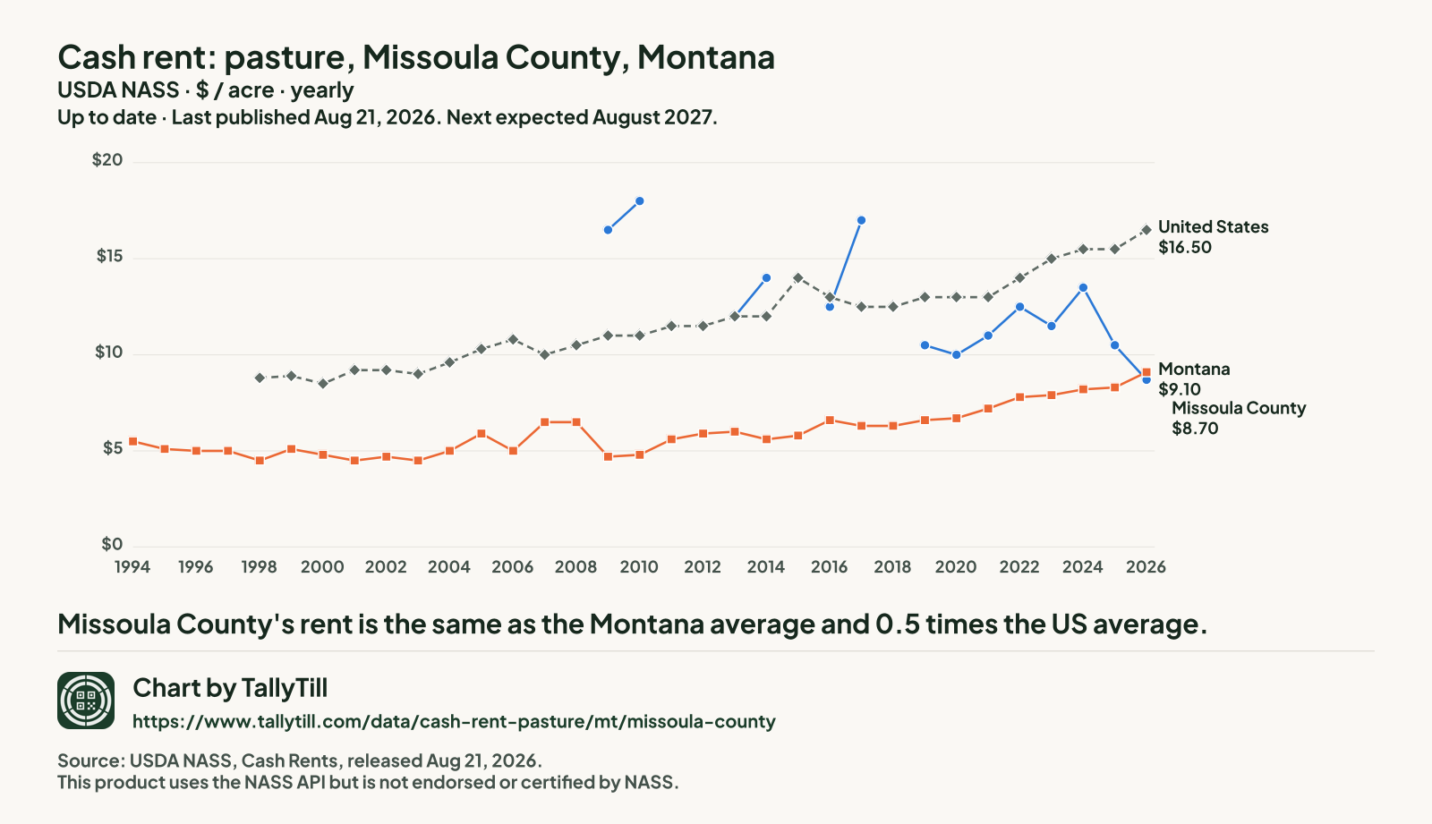
- Missoula County's rent is the same as the Montana average and 0.5 times the US average.
- It is tied for the 20th lowest of the 48 Montana counties NASS published for 2026.
- Since 2009 it has fallen 47.3%, from $16.50 to $8.70 an acre.
- Gaps are years with no separate Missoula figure: NASS ran no county survey in 2015 or 2018, in 2011 and 2012 it combined Missoula into "other counties", and NASS had no figure available in 2008. Nothing is filled in.
Every figure behind this chart
| Year | Missoula County | Montana | United States |
|---|---|---|---|
| 2026 | $8.70 | $9.10 | $16.50 |
| 2025 | $10.50 | $8.30 | $15.50 |
| 2024 | $13.50 | $8.20 | $15.50 |
| 2023 | $11.50 | $7.90 | $15 |
| 2022 | $12.50 | $7.80 | $14 |
| 2021 | $11 | $7.20 | $13 |
| 2020 | $10 | $6.70 | $13 |
| 2019 | $10.50 | $6.60 | $13 |
| 2018 | No county survey that year | $6.30 | $12.50 |
| 2017 | $17 | $6.30 | $12.50 |
| 2016 | $12.50 | $6.60 | $13 |
| 2015 | No county survey that year | $5.80 | $14 |
| 2014 | $14 | $5.60 | $12 |
| 2013 | $12 | $6 | $12 |
| 2012 | Combined into "other counties" | $5.90 | $11.50 |
| 2011 | Combined into "other counties" | $5.60 | $11.50 |
| 2010 | $18 | $4.80 | $11 |
| 2009 | $16.50 | $4.70 | $11 |
| 2008 | Not available | $6.50 | $10.50 |
| 2007 | No figure | $6.50 | $10 |
| 2006 | No figure | $5 | $10.80 |
| 2005 | No figure | $5.90 | $10.30 |
| 2004 | No figure | $5 | $9.60 |
| 2003 | No figure | $4.50 | $9 |
| 2002 | No figure | $4.70 | $9.20 |
| 2001 | No figure | $4.50 | $9.20 |
| 2000 | No figure | $4.80 | $8.50 |
| 1999 | No figure | $5.10 | $8.90 |
| 1998 | No figure | $4.50 | $8.80 |
| 1997 | No figure | $5 | No figure |
| 1996 | No figure | $5 | No figure |
| 1995 | No figure | $5.10 | No figure |
| 1994 | No figure | $5.50 | No figure |
Every Montana county, 2026
Darker shading means a higher figure. Values run from $4.40 an acre in Treasure County to $29 an acre in Ravalli County.
- Under $7.30 (9 counties)
- $7.30 to under $8.70 (10 counties)
- $8.70 to under $10.50 (7 counties)
- $10.50 to under $13.50 (12 counties)
- $13.50 and over (10 counties)
- Not published separately (8 counties, $12.50 an acre combined)
NASS combined Beaverhead County, Deer Lodge County, Granite County, Lewis and Clark County, Liberty County, Lincoln County, McCone County and Mineral County into "other counties", so they have no figure of their own.
| Rank | County | Figure (dollars an acre) | Precision (CV) |
|---|---|---|---|
| 1 | Ravalli County | $29 | 5.7% |
| 2 | Lake County | $22 | 15.7% |
| 3 | Pondera County | $16.50 | 11.5% |
| 4 | Flathead County | $16 | 8.7% |
| 5 | Gallatin County | $14.50 | 12.1% |
| 5 | Judith Basin County | $14.50 | 5.4% |
| 7 | Cascade County | $14 | 8.1% |
| 8 | Broadwater County | $13.50 | 7.8% |
| 8 | Petroleum County | $13.50 | 8.6% |
| 8 | Wibaux County | $13.50 | 6.3% |
| 11 | Golden Valley County | $12.50 | 21.5% |
| 12 | Park County | $12 | 36.6% |
| 12 | Toole County | $12 | 24.5% |
| 14 | Fallon County | $11.50 | 7.2% |
| 14 | Teton County | $11.50 | 5.9% |
| 16 | Fergus County | $11 | 9.2% |
| 16 | Madison County | $11 | 14.8% |
| 16 | Valley County | $11 | 9.4% |
| 19 | Carter County | $10.50 | 21.2% |
| 19 | Chouteau County | $10.50 | 6.2% |
| 19 | Daniels County | $10.50 | 8.8% |
| 19 | Hill County | $10.50 | 10.5% |
| 23 | Carbon County | $10 | 7.2% |
| 23 | Phillips County | $10 | 6.6% |
| 25 | Blaine County | $9.60 | 11.7% |
| 26 | Stillwater County | $9.50 | 6.8% |
| 27 | Roosevelt County | $9.30 | 5.3% |
| 28 | Missoula County This county | $8.70 | 7.4% |
| 28 | Powell County | $8.70 | 14.3% |
| 30 | Richland County | $8.60 | 10.1% |
| 30 | Silver Bow County | $8.60 | 9.6% |
| 32 | Meagher County | $8.50 | 14.1% |
| 33 | Dawson County | $8.30 | 9.1% |
| 34 | Sweet Grass County | $8.10 | 17.6% |
| 35 | Glacier County | $8 | 11.5% |
| 35 | Jefferson County | $8 | 12.4% |
| 35 | Sheridan County | $8 | 5.5% |
| 38 | Garfield County | $7.40 | 17.0% |
| 39 | Powder River County | $7.30 | 7.2% |
| 40 | Wheatland County | $7.10 | 6.8% |
| 41 | Big Horn County | $6.90 | 7.2% |
| 42 | Rosebud County | $6.70 | 5.5% |
| 43 | Yellowstone County | $6.50 | 23.5% |
| 44 | Prairie County | $6 | 8.3% |
| 45 | Custer County | $5.90 | 7.6% |
| 46 | Musselshell County | $5.60 | 5.1% |
| 47 | Sanders County | $4.70 | 5.0% |
| 48 | Treasure County | $4.40 | 11.5% |
What this measures
NASS asks farm operators what they pay in cash rent per acre, separately for irrigated cropland, non-irrigated cropland and pasture. State figures come out at the end of July; county figures follow in August. When too few farms in a county answer, NASS combines that county with others and publishes one "other counties" figure, so some counties have no figure of their own.